|
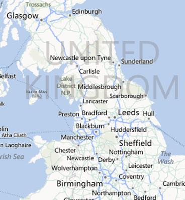
CARLISLE |
|
DAY FIVE |
||||
|
From |
CARLISLE |
to |
LEYLAND |
|
|
CURRENT ROAD |
NEXT INSTRUCTION |
|
DISTANCE to INSTRUCTION |
TOTAL MILEAGE |
|
U/C |
LOWTHER STREET |
|
0 |
0 |
|
U/C |
TURN RIGHT |
|
0.1 |
0.1 |
|
U/C |
TURN LEFT A7 |
|
0.2 |
0.3 |
|
A7 |
TURN RIGHT SPENCER STREET |
|
0.15 |
0.45 |
|
A7 |
BEAR RIGHT AGLIONBY STREET |
|
0.3 |
0.75 |
|
A7 |
TURN LEFT A6 BOTCHERGATE |
|
0.1 |
0.85 |
|
A6 |
EXIT STRIAGHT ON R/A |
|
3 |
3.85 |
|
A6 |
BEAR LEFT |
|
0.2 |
4.05 |
|
A6 |
EXIT BEAR LEFT R/A INGLEWOOD ROAD |
12 |
16.05 |
|
|
A6 |
TURN RIGHT |
|
2.3 |
18.35 |
|
A6 |
KEEP LEFT MARKET SQUARE |
|
0.2 |
18.55 |
|
A6 |
EXIT RIGHT R/A |
|
0.75 |
19.3 |
|
A6 |
BEARLEFT |
|
0.2 |
19.5 |
|
A6 |
TURN LEFT A6 |
|
25 |
44.5 |
|
A6 |
TURN LEFT A65 NEW ROAD |
|
0.25 |
44.75 |
|
A65 |
TURN LEFT BRIDGE STREET |
|
0.2 |
44.95 |
|
A65 |
KEEP RIGHT AYNAM STREET |
|
0.5 |
45.45 |
|
A65 |
TURN RIGHT LOUND ROAD |
|
0.02 |
45.47 |
|
A65 |
BEAR LEFT A6 MILNTHORPE ROAD |
|
0.01 |
45.48 |
|
A6 |
EXIT LEFT R/A A591 |
|
1.2 |
46.68 |
|
A591 |
BEAR LEFT NANNYPIE LANE |
|
2 |
48.68 |
|
U/C |
EXIT RIGHT R/A A590 |
|
0.2 |
48.88 |
|
A590 |
BEAR LEFT |
|
0.15 |
49.03 |
|
A590 |
BEAR LEFT A6 |
|
0.45 |
49.48 |
|
A6 |
TURN LEFT |
|
0.75 |
50.23 |
|
A6 |
EXIT BEAR RIGHT R/A |
|
8.3 |
58.53 |
|
A6 |
BEAR LEFT |
|
0.1 |
58.63 |
|
A6 |
EXIT BEAR RIGHT R/A |
|
0.05 |
58.68 |
|
A6 |
BEAR LEFT |
|
0.1 |
58.78 |
|
A6 |
EXIT STRAIGHT ON R/A SCOTLAND ROAD |
0.3 |
59.08 |
|
|
A6 |
KEEP RIGHT A6 CATON STREET |
|
6.8 |
65.88 |
|
A6 |
TURN LEFT PARLIAMENT STREET |
|
0.3 |
66.18 |
|
A6 |
EXIT STRAIGHT ON R/A GREAVES ROAD |
0.9 |
67.08 |
|
|
A6 |
EXIT BEAR RIGHT R/A |
|
4.3 |
71.38 |
|
A6 |
TURN LEFT B6430 LANCASTER ROAD |
|
5.1 |
76.48 |
|
B6430 |
BEAR LEFT MARKET PLACE |
|
1 |
77.48 |
|
B6430 |
TURN LEFT A6 |
|
2.2 |
79.68 |
|
A6 |
EXIT STRAIGHT OVER R/A |
|
5.5 |
85.18 |
|
A6 |
BEAR LEFT GARSTANG ROAD |
|
0.1 |
85.28 |
|
A6 |
BEAR LEFT GARSTANG ROAD |
|
0.1 |
85.38 |
|
A6 |
BEAR LEFT NORTH ROAD |
|
2.3 |
87.68 |
|
A6 |
BEAR LEFT RING WAY |
|
0.45 |
88.13 |
|
A6 |
BEAR RIGHT LONDON WAY |
|
1.4 |
89.53 |
|
A6 |
EXIT BEAR LEFT R/A LONDON WAY |
|
0.65 |
90.18 |
|
A6 |
EXIT STRAIGHT ON R/A |
|
1 |
91.18 |
|
A6 |
EXIT RIGHT R/AA582 LOSTOCK LANE |
|
0.1 |
91.28 |
|
A582 |
BEAR LEFT |
|
0.1 |
91.38 |
|
A582 |
BEAR LEFT A5083 |
|
0.35 |
91.73 |
|
A5083 |
TURN LEFT B5254 CHURCHHILL WAY |
|
1.8 |
93.53 |
|
B5254 |
EXIT RIGHT R/A |
|
0.2 |
93.73 |
|
|
|
TOTAL |
93.73 |
|